


Toronto Real Estate & Homes for Sale
Toronto, Ontario
From Wikipedia, the free encyclopedia
Toronto is the largest city in Canada and the provincial capital of Ontario. It is located in Southern Ontario on the northwestern shore of Lake Ontario. Toronto is a relatively modern city. Its history begins in the late 18th century, when the British Crown purchased its land from the Mississaugas of the New Credit. The British established a settlement there, called the Town of York, which its lieutenant governor, John Graves Simcoe, designated as the capital of Upper Canada. The city was ransacked in the Battle of Yorkduring the War of 1812. In 1834, York was incorporated as a city and renamed Toronto. It was damaged in two huge fires, in 1849 and 1904. Over the years, Toronto has several times expanded its borders through amalgamation with surrounding municipalities, most recently in 1998.
The city has 2.6 million residents, according to the 2011 Census. It is currently the fifth most populous city in North America. The census metropolitan area (CMA) had a population of 5,583,064, and the Greater Toronto Area (GTA) had a population of 6,054,191 in the 2011 Census. Toronto is at the heart of the Greater Toronto Area, and of the densely populated region in Southern Ontario known as the Golden Horseshoe. Its cosmopolitan and international population reflects its role as an important destination for immigrants to Canada.Toronto is one of the world's most diverse cities by percentage of non-native-born residents, with about 49% of the population born outside Canada. As Canada's commercial capital, it is home to the Toronto Stock Exchange and some of the nation's largest banks.

Demographics
The city's population grew by 4% (96,073 residents) between 1996 and 2001, 1% (21,787 residents) between 2001 and 2006, and 4.3% (111,779 residents) between 2006 and 2011. Persons aged 14 years and under made up 17.5% of the population, and those aged 65 years and over made up 13.6%. The median age was 36.9 years. Foreign-born people made up 49.9% of the population. The city's gender population is 48% male and 52% female. However, women outnumber men in all age groups over 20. As of 2006, 46.9% of the residents of the city proper belong to a visible minority group, and visible minorities are projected to comprise a majority in the Toronto CMA by 2017. In 1981, Toronto's visible minority population was 13.6%.
According to the United Nations Development Programme, Toronto has the second-highest percentage of constant foreign-born population among world cities, after Miami, Florida. While Miami's foreign-born population consists mostly of Cubans and other Latin Americans, no single nationality or culture dominates Toronto's immigrant population, placing it among the most diverse cities in the world. By 2031, Toronto's current visible minority population will have increased to 63%, changing the definition of visible minority in the city. More than 100,000 immigrants arrive in the Toronto area every year.
In 2006, a majority of Torontonians claimed their ethnic origins from as either in whole or part from England (15.9%), Canada (12.8%), Scotland (11.1%), China (10.6%), Ireland (10.5%), India(9.6%), Italy (9.2%), Germany (5.1%), France (4.8%), Poland (4.1%), Portugal (3.7%), the Philippines (3.6%), and Jamaica (3.2%). The five largest visible minority groups in Toronto areSouth Asian (12.0%), Chinese (11.4%), Black (8.4%), Filipino (4.1%) and Latin American (2.6%). Aboriginal peoples, who are not considered visible minorities, formed 0.5% of the population. This diversity is reflected in Toronto's ethnic neighbourhoods, which include Chinatown, Corso Italia, Greektown, Kensington Market, Koreatown, Little India, Little Italy, Little Jamaica, Little Portugal and Roncesvalles.
Christianity is the largest religious group in Toronto. The 2001 Census reports that 33.4% of the city's population is Catholic, followed by Protestant (21.1%), Christian Orthodox at (4.8%), Coptic Orthodox (0.2%), and other Christians (3.9%). With the city's significant number of Methodist Christians, Toronto was sometimes referred to as the Methodist Rome. Other religions in the city are Islam (5.5%), Hinduism (4.1%), Judaism (3.5%), Buddhism (2.1%), Sikhism(1.9%), and other Eastern religions (0.2%). 16.6% of the population professes no religion.
While English is the predominant language spoken by Torontonians, many other languages have considerable numbers of local speakers. The varieties of Chinese and Italian are the second and third most widely spoken languages at work. As a result, the city's 9-1-1 emergency services are equipped to respond in over 150 languages.
Economy
Toronto is an international centre for business and finance. Generally considered the financial capital of Canada, Toronto has a high concentration of banks and brokerage firms on Bay Street, in the Financial District. The Toronto Stock Exchange is the world's seventh-largest stock exchange by market capitalization. The five largest financial institutions of Canada, collectively known as the Big Five, have national offices in Toronto.
The city is an important centre for the media, publishing, telecommunication, information technology and film production industries; it is home to Bell Media, Rogers Communications, andTorstar. Other prominent Canadian corporations in the Greater Toronto Area include Magna International, Celestica, Manulife Financial, Sun Life Financial, the Hudson's Bay Company, and major hotel companies and operators, such as Four Seasons Hotels and Fairmont Hotels and Resorts.
Although much of the region's manufacturing activities take place outside the city limits, Toronto continues to be a wholesale and distribution point for the industrial sector. The city's strategic position along the Quebec City – Windsor Corridor and its road and rail connections help support the nearby production of motor vehicles, iron, steel, food, machinery, chemicals and paper. The completion of the Saint Lawrence Seaway in 1959 gave ships access to the Great Lakes from the Atlantic Ocean.
The city's net debt stood at $4.4 billion as of the end of 2010 and has a AA credit rating. Toronto is expected to pay $400 million of the debt in 2011. The city's debt increased by $721 million in 2010. The city’s unemployment rate was 8.1% in November 2011, down from 8.3% year over year. The cost of living in Toronto was ranked highest in Canada in 2011.

Transportation
Toronto's public transportation system is operated by the Toronto Transit Commission (TTC). The backbone of its public transport network is the Toronto subway and RT, which includes three heavy-rail rapid transit lines and a mainly elevated light-metro rapid transit line that runs in Scarborough. The TTC also operates a network of buses and streetcars. There have been numerous plans to extend the subway and implement light-rail lines, but many efforts have been thwarted by budgetary concerns. Since July 2011, the only subway-related work is the Spadina subway extension north of Downsview Station.
The Government of Ontario also operates an interregional rail and bus transit system called GO Transit in the Greater Toronto Area. GO Transit carries over 217,000 passengers every weekday and 57 million annually, with a majority of them travelling to or from Union Station.
Canada's busiest airport, Toronto Pearson International Airport (IATA: YYZ), straddles the city's western boundary with the suburban city of Mississauga. Limited commercial and passenger service is also offered from the Billy Bishop Toronto City Airport, on the Toronto Islands, southwest of downtown. Toronto/Buttonville Municipal Airport in Markham provides general aviation facilities. Toronto/Downsview Airport, near the city's north end, is owned by de Havilland Canada and serves the Bombardier Aerospace aircraft factory.
There are a number of municipal expressways and provincial highways that serve Toronto and the Greater Toronto Area. In particular, Highway 401 bisects the city from west to east, bypassing the downtown core. It is the busiest road in North America, and one of the busiest highways in the world. The main municipal expressways in Toronto include the Gardiner Expressway, the Don Valley Parkway, and to some extent, Allen Road.
The grid of major city streets was laid out by a concession road system, in which major arterial roads are 6,600 ft (2.0 km) apart. Major east-west arterial roads are generally parallel with the Lake Ontario shoreline, and major north-south arterial roads are roughly perpendicular to the shoreline. This arrangement is sometimes broken by geographical accidents, most notably the Don River ravines.

Public Spaces
Toronto has a diverse array of public spaces, from city squares to public parks overlooking ravines. A group called the Toronto Public Space Committee was formed to protect the city's public spaces. Nathan Phillips Square is the city's main square in downtown, and forms the entrance to City Hall. Yonge-Dundas Square, a newer, privately owned square near to City Hall, has also gained attention in recent years as one of the busiest gathering spots in the city. Other squares include Harbourfront Square, on the revitalized Toronto waterfront, and the civic squares at the former city halls of the defunct Metropolitan Toronto, most notably Mel Lastman Square in North York.
There are many large downtown parks, which include Grange Park, Moss Park, Allan Gardens, Little Norway Park, Queen's Park, Riverdale Park, Trinity Bellwoods Park, Christie Pits, and theLeslie Street Spit, which mainly consists of Tommy Thompson Park and opens on weekends. The Toronto Islands have several acres of park space, accessible from downtown by ferry. Large parks in the outer areas include High Park, Humber Bay Park, Centennial Park, Downsview Park, Guildwood Park, and Rouge Park. An almost hidden park is the compact Cloud Gardens,which has both open areas and a glassed-in greenhouse in downtown Toronto.
Nathan Phillips Square, Harbourfront Centre, and Mel Lastman Square feature popular rinks for public ice-skating. Etobicoke's Colonel Sam Smith Trail opened in 2011 and is Toronto's first skating trail. Centennial Park and Earl Bales Park offer outdoor skiing and snowboarding slopes with a chair lift, rental facilities, and lessons.
Nathan Phillips Square is undergoing a major redesign by PLANT Architect Inc., Shore Tilbe Irwin + Partners, Peter Lindsay Schaudt Landscape Architecture Inc., and Adrian Blackwell (winners of the international design competition in 2007). West 8, a Dutch architecture firm, won the Central Waterfront Innovative Design Competition in 2006 to redesign the central part of the Toronto waterfront. In 1999, Downsview Park initiated an international design competition to realise its vision of creating Canada's first national urban park. In May 2000, the winning park design was announced: "TREE CITY", by the team of Bruce Mau Design, Office for Metropolitan Architecture, Oleson Worland Architect and Inside/Outside.
Neighborhoods
The many residential communities of Toronto express a character distinct from that of the skyscrapers in the commercial core. Victorian and Edwardian-era residential buildings can be found in enclaves such as Rosedale, Cabbagetown, The Annex, and Yorkville. Wychwood Park is historically significant for the architecture of its homes, and for being one of Toronto's earliest planned communities. The Wychwood Park neighbourhood was designated as an Ontario Heritage Conservation district in 1985. The Casa Loma neighbourhood is named after Casa Loma, a storybook castle built in 1911 complete with gardens, turrets, stables, an elevator, secret passages, and a bowling alley. Spadina House is a 19th century manor that is now a museum.
The City of Toronto encompasses a geographical area formerly administered by six separate municipalities. These municipalities have each developed a distinct history and identity over the years, and their names remain in common use among Torontonians. Throughout the city there exist hundreds of small neighbourhoods and some larger neighbourhoods covering a few square kilometres. Former municipalities include East York, Etobicoke, North York, Old Toronto, Scarborough, and York.
Old Toronto
The Old City of Toronto covers the area generally known as downtown, but also older neighbourhoods to the east, west, and north of downtown. It includes the historic core of Toronto and remains the most densely populated part of the city. The Financial District contains the First Canadian Place, Toronto-Dominion Centre, Scotia Plaza, Royal Bank Plaza, Commerce Court and Brookfield Place. This area includes, among others, the neighbourhoods of St. James (not to be confused with St. James Town to the north), Garden District, St. Lawrence, Corktown, and Church and Wellesley. From that point, the Toronto skyline extends northward along Yonge Street. Old Toronto is also home to many historically wealthy residential enclaves, such as Yorkville, Rosedale, The Annex, Forest Hill, Lawrence Park, Lytton Park, Deer Park, Moore Park, and Casa Loma, most stretching away from downtown to the north. East and west of Downtown, neighbourhoods such asKensington Market, Chinatown, Leslieville, Cabbagetown and Riverdale are home to bustling commercial and cultural areas as well as communities of artists with studio lofts, with many middle and upper class professionals. Other neighbourhoods in the central city retain an ethnic identity, including two Chinatowns, the Greektown area, Little Italy,Portugal Village, and Little India, along with others.
Suburbs
The inner suburbs are contained within the former municipalities of York and East York. These are mature and traditionally working class areas, primarily consisting of post–World War I small, single-family homes and small apartment blocks. Neighbourhoods such as Crescent Town, Thorncliffe Park, Weston, and Oakwood–Vaughan mainly consist of high-rise apartments, which are home to many new immigrant families. During the 2000s, many neighbourhoods have become ethnically diverse and have undergonegentrification, as a result of increasing population and a housing boom during the late 1990s and first decade of the 21st century. The first neighbourhoods affected wereLeaside and North Toronto, gradually progressing into the western neighbourhoods in York. Some of the area's housing is in the process of being replaced or remodelled.
The outer suburbs comprising the former municipalities of Etobicoke (west), Scarborough (east) and North York (north) largely retain the grid plan laid before post-war development. Sections were long established and quickly growing towns before the suburban housing boom began and the emergence of Metro Government, existing towns or villages such as Mimico, Islington and New Toronto in Etobicoke; Willowdale, Newtonbrook and Downsview in North York; Agincourt, Wexford and West Hill in Scarborough where suburban development boomed around or between these and other towns beginning in the late 1940s. Upscale neighbourhoods were built such as the Bridle Path in North York, the area surrounding the Scarborough Bluffs in Guildwood, and most of central Etobicoke, such as Humber Valley Village, and The Kingsway. One of largest and earliest "planned communities" was Don Mills, parts of which were first built in the 1950s. Phased development mixing single-detached housing with higher density apartment blocks became more popular as a suburban model of development. Over the late 20th century and early 21st century, North York City Centre, Etobicoke City Centre and Scarborough City Centre have emerged as secondary business districts outside Downtown Toronto. High-rise development in these areas have given the former municipalities distinguishable skylines of their own with high-density transit corridors serving them.
World City Rankings
Toronto is considered an alpha world city by the Globalization and World Cities (GaWC) study group. Toronto's leading economic sectors include finance, business services, telecommunications, aerospace, transportation, media, arts, publishing, software production, medical research, education, tourism, and engineering. The city is also consistently rated as one of the world's most livable cities by the Economist Intelligence Unit and the Mercer Quality of Living Survey.
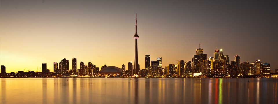
Geography
Toronto covers an area of 630 square kilometres (243 sq mi), with a maximum north-south distance of 21 kilometres (13 mi) and a maximum east-west distance of 43 km (27 mi). It has a 46-kilometre (29 mi) long waterfront shoreline, on the northwestern shore of Lake Ontario. The Toronto Islands and Port Lands extend out into the lake, allowing for a somewhat shelteredToronto Harbour south of the downtown core. The city's borders are formed by Lake Ontario to the south, Etobicoke Creek and Highway 427 to the west, Steeles Avenue to the north and the Rouge River and the Scarborough-Pickering Townline to the east.
Real Estate Aurora - Real Estate Buttonville - Real Estate Maple - Real Estate Markham - Real Estate Newmarket - Real Estate Richmond Hill - Real Estate Thornhill - Real Estate Toronto - Real Estate Unionville - Real Estate Vaughan - Real Estate Whitchurch-Stouffville - Real Estate Woodbridge